The CIA World DataBank II is a collection of world map data, consisting of vector descriptions of land outlines, rivers, and political boundaries. It was created by the U.S. government in the 1980s. A highly compressed binary version of the data has been available on the Internet from several sources, but the format of this data is a bit complex and not well documented except by some example C code. Given the continual increase in hard disk sizes and network bandwidth, it's not as vital now to compress the data so much, so I have created plain text versions that are easier to use.
The complete text version of the WDB is here, in WDB-text.tar.gz. The compressed tar file is 30 megabytes; uncompressed, the files are a total of 121 megabytes.
Separate tar files containing individual continents are also available:
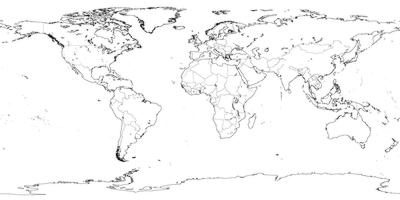
Some images that I generated from this data are available on my Earth maps page. The simple black & white images are handy for compositing over other maps.
Copies of the older binary versions of the data are at
http://sepwww.stanford.edu/ftp/World_Map/
The program that I wrote (based on 'domap.c' from the binary version) to convert these files to text is:
wdb2text.c