
Rocky Mountain Mapping Center Builds and Develops GeoWall System
April 1st, 2003 - May 1st, 2003
Categories: Applications, Devices
About
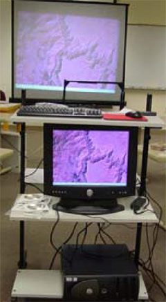
The latest news from the GeoWall Consortium is the Rocky Mountain Mapping Center (RMMC), in cooperation with the USGS Central Region Director, has assembled a GeoWall system for use by USGS scientists and other partners.
Coined the “RockyWall”, RMMC has focused upon getting the GeoWall system operational by first using data readily available over the internet. This stage successfully accomplished led to the development of 3D visualizations using RMMC data of the Hayman IFSAR data a high resolution elevation data set derived from a synthetic aperture radar over the Hayman Fire area. The success of these effort have allowed the RMMC to reach its first year goals, and have contributed to reaching their ultimate goal of creating a USGS Central Region Visualization facility to foster collaboration and scientific discovery for USGS and DOI scientist and managers.
EVL’s research efforts continue to be rewarded by the successes of such groups as the RMMC, and the growing community of GeoWall adopters.