
Understanding Transportation Accessibility of Metropolitan Chicago Through Interactive Visualization
November 3rd, 2015
Categories: Applications, Visualization, Visual Informatics
Authors
Yin, S., Li, M., Tilahun, N., Forbes, A. G., Johnson, A. E.About
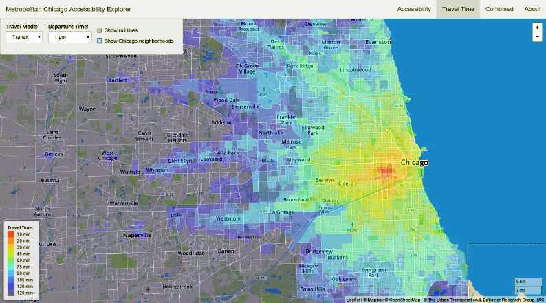
Accessibility is an important element in urban transportation planning. Accessibility measures combine mobility and land use measures to provide a more complete picture of the transportation-land use nexus than either of these measures alone. By providing insights into the varying degrees to which different areas of a region are connected to opportunities by the transportation system, accessibility analysis helps urban planners to understand the relationship between transportation and land use, and provides reference for them to improve the equality of the residents. Calculating accurate accessibility values and visualizing them in an efficient way is a complex and challenging process. In this paper, we present a web-based system that visualizes multimodal
accessibility to multiple land uses of Chicago metropolitan area, as the first step of an effort to build an integrated platform for accessibility analysis tasks. We also discuss some use cases of this system, and show its effectiveness by providing experts feedback of this prototype.
Categories and Subject Descriptors
I.3.8 [Computer Graphics]: Applications; H.5.2 [Information Interfaces and Presentation]: User Interfaces|graphical user interfaces
General Terms
Design
Keywords
accessibility analysis, geographic visualization, urban transportation planning
Resources
Citation
Yin, S., Li, M., Tilahun, N., Forbes, A. G., Johnson, A. E., Understanding Transportation Accessibility of Metropolitan Chicago Through Interactive Visualization, In Proceedings of the ACM SIGSPATIAL International Workshop on Smart Cities and Urban Analytics (UrbanGIS), November 3rd, 2015.