
JuxtaView
January 16th, 2002 - January 15th, 2005
Categories: Applications, Software, Visualization
About
JuxtaView is a tool designed specifically for scalable tiled displays to visualize extremely high-resolution images. Scientists are finding an increasing need to display visualizations on extremely high-resolution displays, such as EVL’s 6000x3000-pixel LCD tiled display, called the PerspecTile, driven by a cluster of PCs. JuxtaView employs the MPI communication library to distribute Open GL commands for synchronization of display on all tiles.
JuxtaView manages very large image datasets by using a software based network level cache system called LambdaRAM, a remote data access tool built over the QUANTA networking API. LambdaRAM enables an application to efficiently utilize a collective compute cluster memory to store extraordinarily large data and minimize latency effects by pre-fetching parts of the data before its is likely to be needed. The ultimate goal of JuxtaView is to enable a user to interactively roam through potentially terabytes of distributed, spatially referenced image data such as those from electron microscopes, satellites and aerial photographs.
EVL has been developing this technology to support two domain research areas: Geosciences, in partnership with the Scripps Institution of Oceanography, and Bioscience with the Biomedical Informatics Network Research (BIRN) effort headed by the National Center for Microscopy and Imaging Research at the University of California, San Diego.
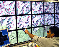
Pictured here is EVL’s Perspectile showing a stereo image of the Grand Canyon. This image from USGS provides a topographical map of the canyon, generated from satellite bathymetry data. These kinds of maps have a variety of applications, including the study of plate tectonics and undersea volcanoes, to name a few.
EVL is also applying this technology to the visualization of aerial photography images provided by the US Geological Survey as part of a homeland defense initiative. In this application, aerial photographs of 133 urban areas are being photographed at a 3-foot resolution. This amounts to a total of approximately 38 Terabytes of image data that JuxtaView must be able to navigate through.
7/2004