
UIC Technology Aids Obama Inaugural Security
January 13th, 2009
Categories: Applications, Devices, Government, Multimedia, Networking, Software, Supercomputing, Tele-Immersion, User Groups, Visualization, VR
About
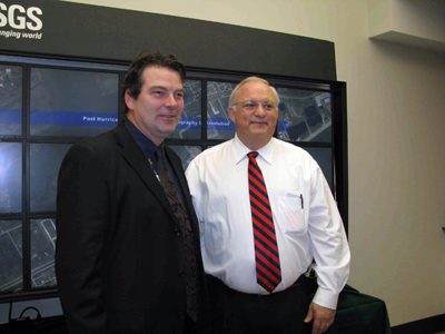
Pictured Right: Brian Davis, a contractor for the USGS EROS Data Center in Sioux Falls, S.D., and James Cason, Deputy Secretary of the Department of the Interior, pose in front of the USGS / EVL OptIPortal tiled display. Mr. Davis briefed Mr. Cason and other DOI officials on how the OptIPortal can be used for response to natural hazards. In this case, post-storm data from Hurricane Ike was showcased.
January 13, 2009
CHICAGO - With more than a million people predicted to descend on Washington, D.C. next Tuesday to witness Barack Obama’s presidential inauguration, many will stake a viewing spot near public monuments or along the Mall - all land supervised by the U.S. Department of the Interior.
While security planning and logistics are daunting, imaging technology developed by UIC’s Electronic Visualization Laboratory is helping to make the job easier.
Planners are using an EVL “OptIPortal” - a wall-sized display of flat-screen LCD monitors that ultra-high-resolution images backed by supercomputer power to provide expansive, razor-sharp, eagle’s eye aerial pictures of the inauguration site.
“All streets but one entering the downtown Mall area enter onto land the Department of Interior is responsible for,” said Brian Davis, a contractor to the U.S. Geological Survey (USGS) who was instrumental in getting the OptIPortal included in the inaugural planning. “Interior will have a huge responsibility for monitoring safety, security, traffic and countless other issues.”
The USGS - the Interior Department’s mapmaking arm - has worked with EVL for the past six years on geological projects using a portable version of the OptIPortal, one of 34 such systems currently being used by scientific groups around the world.
At the request of the Interior Department, it was packed up and shipped from a USGS office in Sioux Falls, S.D. to Interior’s planning center in Northern Virginia for use in training and preparation for the inauguration.
“We heard about it just before Christmas,” says Jason Leigh, associate professor of computer science and EVL’s co-director. “We were really excited to learn that we’d be part of history.”
Interior’s OptIPortal delivers a 35-megapixel image on a wall display measuring some four by eight feet, allowing viewing and discussion by a large group of planners.
“This is like a digital version of the high resolution printed maps that they’re used to working with, but now constantly fed with the latest information,” says Leigh.
Software called “Magic Carpet”, also developed by EVL, enables this feat.
“Magic Carpet is essentially Google Maps on steroids,” says Leigh. “It’s designed to run on a large cluster of computers that drive the OptIPortals, letting you take this high-resolution, multi-resolution imagery and pan and zoom through it quickly.”
EVL has worked with a number of partner agencies and universities in developing the OptIPortal. Funding was provided largely by the National Science Foundation.
Leigh says while OptIPortal users are developing new ways to use this sophisticated technology, EVL researchers are already considering how future high speed networks will change the way we display and interact with massive feeds of information.
And, says Leigh, tomorrow’s displays will be even bigger.
“The walls of our offices, laboratories and homes will be covered by digital wallpaper.”
By Paul Francuch, UICNEWS