
Planetary-scale Terrain Composition, PhD Dissertation Robert L. Kooima
October 23rd, 2008
Categories: Museums, Software, User Groups, Visualization, VR
About
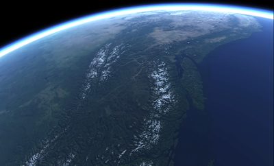
Many inter-related planetary height map and surface image map data sets exist, and more data are collected each day. Broad communities of scientists require tools to compose these data interactively and explore them via real-time visualization. While related, these data sets are often unregistered with one another, having different projection, resolution, format, and type. I present a GPU-centric approach to the real-time composition and display of unregistered-but-related planetary-scale data.
This approach employs a GPU process to tessellate spherical height fields. It uses a render-to-vertex-buffer technique to operate upon polygonal surface meshes in image space, allowing geometry processes to be expressed in terms of image processing. With height and surface map data processing unified in this fashion, a number of powerful composition operations may be universally applied to both. Examples include adaptation to non-uniform sampling due to projection, seamless blending of data of disparate resolution or transformation regardless of boundary, and the smooth interpolation of levels of detail in both geometry and imagery. Issues of scalability and precision are addressed, giving out-of-core access to giga-pixel data sources, and correct rendering at sub-meter scales.
Presentation and Demonstration in The Adler Planetarium’s Definiti Space Theater begins promptly at 6pm.