
Tellurion
January 1st, 2007 - December 30th, 2008
Categories: Applications, Visualization
About
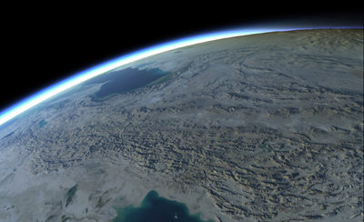
Tellurion is a real-time planetary-scale data visualization. It uses a GPU-based algorithm to adaptively tessellate the sphere and apply terrain displacement, composing height field images of arbitrary resolution and projection. A deferred rendering approach combines per-pixel illumination and atmospheric effects for added realism.
Data sources: NASA’s Blue Marble Next Generation and Shuttle Radar Topography Mission.
Funding provided by the Adler Planetarium & Astronomy Museum and by the National Science Foundation cooperative agreement OCI-0225642 to University of California, San Diego for the OptIPuter project.