
UIC’s Correlator and Corelyzer Software Aids Geoscientists Aboard Scientific Ocean Drilling Expeditions
April 28th, 2009
Categories: Applications, MS / PhD Thesis, Software, User Groups, Visualization
About
Software developed by the University of Illinois at Chicago’s (UIC) Electronic Visualization Laboratory (EVL) has been successfully tested by an international crew of scientists studying equatorial Pacific Ocean climate history using sediment core samples extracted from the ocean’s floor.
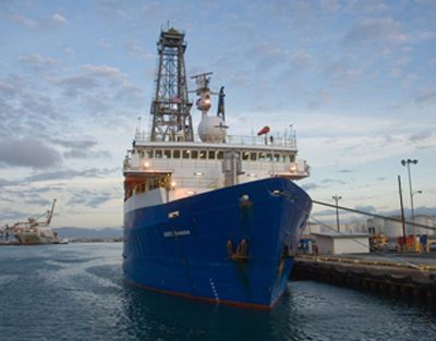
Researchers aboard the scientific drilling vessel JOIDES Resolution used EVL’s Corelyzer software to help them visualize solid, 10-meter-long cylinders of sediment core sample that they drilled from the seabed. These samples can offer a well-preserved climate change record when carefully aligned to build a complete stratigraphic record.
EVL’s Corelyzer software lets geoscientists view high-resolution core imagery as one continuous image. “Intuitively, you may think numerical data is more precise,” said Julian Chen, a UIC doctoral student in computer science. “But we found there is more information contained in the high-resolution image in terms of samples per centimeter.”
The Corelyzer software allows geoscientists to load high-resolution core images produced from downhole geophysical logs and numerical measurements of physical characteristics. Users can then view, magnify, annotate, and juxtapose multiple cores. Optimal visualization of core imagery is facilitated by using two 30-inch LCDs arranged side-by-side.
Multiple core samples are extracted from a drilling site, which must be composited and spliced together to build a complete stratigraphic record. Correlator, another EVL-developed software tool, allows users to digitally correlate multiple-hole cores and restore any compression or stretching of the sediment core that may have occurred during the extraction process.
Correlator replaces two 15-year-old software packages and is deployed in JOIDES Resolution’s Core Lab, where petrophysical and paleomagnetic data is analyzed to correlate adjacent holes and construct a composite depth scale for each drilling site. Prior to Corelyzer, which warehouses a database of images, the Core Lab relied primarily on numerical data and Photoshop to correlate and composite the cores.
Extracted core sections are run through an automatic multi-sensor track system to capture physical properties like magnetic susceptibility, overall density, velocity, and natural gamma-ray activity. The core is then split lengthwise for further analysis and imaged in high-resolution to capture all of its visible features. The split core and all the geophysical data (from the multi-sensor track as well as the log data) are curated and are used for additional specialty research.
“Corelyzer is a mechanism to build a mash-up of images and data, which form a palette on which to start building scientific interpretations,” said Dr. Sean Higgins, research scientist at Columbia University’s Lamont-Doherty’s Borehole Research Group. “The resulting session files can be saved, archived, and distributed among a global community of scientists via web services.”
“Correlator’s data manager is a game changer,” said Higgins, who is also the Associate Director for U.S. Ocean Drilling for the Consortium for Ocean Leadership, and sailed on the JOIDES Resolution sea trials that concluded in March. “Scientists can get the data in and out in an efficient and flexible way, without the need of a programmer to write scripts or format the data. It has essentially stripped away the ‘black box’ functionality.”
The main goal of sea trials was to test out the ship and install all the science systems in preparation for upcoming expeditions. Higgins worked with Chen and UIC computer science doctoral student Hyejung Hur to correct functionality issues identified during the trials. They will continue to support and enhance the system for future expeditions.
In early May, Higgins will attend the port call when JOIDES Resolution completes its first leg of IODP Expedition 320, dubbed the Pacific Equatorial Age Transect (PEAT) expedition. “The PEAT expedition is trying to create a complete time sequence of the last 60 million years of Pacific equatorial activity, and to show how it has changed,” said Higgins.
The drill ship is scheduled over the next year to conduct expeditions in the equatorial Pacific, heading north to the Juan de Fuca Ridge off the west coast of North America, then further north to the Bering Sea, south to the Shatsky Rise off the eastern coast of Japan, then Canterbury Basin off New Zealand, and Wilkes Land, Antarctica.
About CoreWall www.corewall.org
CoreWall is a real-time stratigraphic correlation, core description, and data visualization system used by the marine, terrestrial, and Antarctic science communities. CoreWall’s Corelyzer has already been deployed in Antarctica for two field seasons as part of ANDRILL (Antarctic Drilling Program). CoreWall’s Corelyzer and Correlator was most recently deployed on the JOIDES Resolution for Integrated Ocean Drilling Project Expedition 320, dubbed the Pacific Equatorial Age Transect (PEAT) expedition. CoreWall partners include University of Minnesota, Twin Cities; University of Illinois at Chicago; Lamont-Doherty Earth Observatory; Insight Access Group Partners; and Institute of Arctic and Alpine Research.
About JOIDES Resolution joidesresolution.org
The JOIDES Resolution operates as part of the international Integrated Ocean Drilling Program (IODP) with funding from the U.S. National Science Foundation. The U.S. Implementing Organization for IODP is comprised of Texas A&M University, Columbia University’s Lamont-Doherty Earth Observatory, and the Consortium for Ocean Leadership. JOIDES Resolution recently underwent a $130 million renovation and is set to resume international operations after a 3-year hiatus. Its latest exploration, IODP Expedition 320, dubbed the Pacific Equatorial Age Transect (PEAT) expedition, is exploring climate history along the paleo-Pacific equator over the period of 20 to 60 million years ago.