
CoreWall
May 16th, 2004 - May 15th, 2011
Categories: Applications, Devices, Visualization
About
CoreWall is an integrated visualization tool for the study of lake and ocean sediment cores. It is a collaborative project among the University of Illinois at Chicago’s Electronic Visualization Laboratory (EVL), U.S. National Lacustrine Core Repository (LacCore) at the University of Minnesota, and the Integrated Ocean Drilling Program (IODP) through Joint Oceanographic Institutions, a non-profit corporation located in Washington, D.C.
CoreWall’s software displays section images from one or more cores along with discrete data streams and nested images to provide a robust approach to the description of sediment cores. CoreWall creates virtual initial core description (ICD) sheets on-the-fly as data is added. This tool enables rapid multidisciplinary interpretation during the ICD process. Such interpretation is commonly done when preparing initial reports or papers for scientific journals.
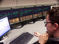
CoreWall’s high-resolution tiled-LCD display format gives geoscientists a large-scale perspective, helpful in processing and comparing high-resolution digital line-scan images of cores measuring up to hundreds of feet long.
Split-core surface images are the fundamental template of sediment descriptive work. Loaded horizontally and viewed in high resolution along a sliding plane, features such as lithologic variation, macroscopic grain size variation, bioturbation intensity, chemical composition and micropaleontology are easier to interpret and annotate.
CoreWall users can interface to a database of core images and sensor logs, and also fetch data from remote CoreWall repositories. Future plans include linking to the JANUS Ocean Drilling Program database at Texas A&M University.
A prototype desktop environment for CoreWall is Personal GeoWall2 (PG2), a system that uses a single computer to drive four LCD panels as well as a single screen stereo GeoWall display. The combination allows geoscientists to juxtapose high-resolution core images and sensor data next to fully stereoscopic visualizations.