
Corelyzer: Scalable Geologic Core Visualization using OSX, Java and OpenGL
July 8th, 2006
Categories: Applications, Architecture, MS / PhD Thesis, Visualization
Authors
Rao, A., Chen, Y., Lee, S., Leigh, J., Johnson, A., Renambot, L.About
Ice cores drilled from lake and ocean floors, continents, and ice sheets provide geoscientists with the most extensive and accurate picture of the Earth’s climate history. For decades, these stratigraphic records have been locked in core repositories around the world. Now, aided by modern information technologies and advanced equipment like high-resolution color line-scanners and multi-sensor data loggers, core data can be digitized to create large amounts of high-precision digital images and numerical data.
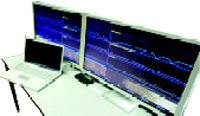
Corelyzer allows geoscientists to collaborate over huge data visualizations in a desktop workstation using single or multiple monitors with great interactivity and scalability. The main user-interface was developed in Java with native methods for efficient rendering with the OpenGL implementation on Mac OS X. A multiple level-of-detail texture paging system is implemented inside Corelyzer that allows scientists to load and interact with thousands of meters of geological cores, for which approximately one kilometer produces 30 GB of raw imagery.
With the ability to display core sections in high resolution, Corelyzer is best viewed on tiled 30 inch Apple Cinema Displays. Corelyzer can scale to display on multiple large displays run by a single computer all the way down to the new MacBook. Future development will incorporate the use of a table of Apple displays driven by a cluster.
Extensibility is also a priority of Corelyzer, so that the visualization tool can be customized. Examples by individual organizations include: heterogeneous database access, image analysis and Persistent Multi-user Online Collaborative Scientific Visualization (PMOCSV).
In October 2006, Corelyzer will be deployed at the ANDRILL project’s McMurdo expedition station. ANDRILL is the newest geological drilling program to recover stratigraphic records from the Antarctic region.
Corelyzer is being developed by the University of Illinois at Chicago’s Electronic Visualization Laboratory with funding provided by the National Science Foundation.
Resources
Citation
Rao, A., Chen, Y., Lee, S., Leigh, J., Johnson, A., Renambot, L., Corelyzer: Scalable Geologic Core Visualization using OSX, Java and OpenGL, Apple’s Worldwide Developers Conference 2006, July 8th, 2006.